Eyeballing
Guantanamo Bay Naval Base Facilities
Marine Sentry, 1916
![[Image]](pict31.jpg)


|
|||||||
|
Cryptome DVDs are offered by Cryptome. Donate $25 for two DVDs of the Cryptome 12-years collection of 46,000 files from June 1996 to June 2008 (~6.7 GB). Click Paypal or mail check/MO made out to John Young, 251 West 89th Street, New York, NY 10024. The collection includes all files of cryptome.org, jya.com, cartome.org, eyeball-series.org and iraq-kill-maim.org, and 23,000 (updated) pages of counter-intelligence dossiers declassified by the US Army Information and Security Command, dating from 1945 to 1985.The DVDs will be sent anywhere worldwide without extra cost. | ||||||
11 September 2006
See also:
http://eyeball-series.org/gitmo-courts.htm
http://eyeball-series.org/gitmov/gitmov-eyeball.htm
http://eyeball-series.org/gtmo-eyeball.htm
http://eyeball-series.org/gitmo-build/gitmo-build.htm
http://eyeball-series.org/gitmo6/gitmo-061606.htm
http://eyeball-series.org/gitmo5/gitmo-052205.htm
http://eyeball-series.org/gitmo4-eyeball.zip
http://eyeball-series.org/gitmo-eyeball.htm
Since Guantanamo Bay Naval Base was selected after 9/11 to house alleged terrorist detainees there have not been many aerial photographs published of its facilities, presumably for security reasons. The Department of Defense Visual Information Center offers nearly earlier 800 photos of the base, with several dozen high-resolution aerial photos showing the facilities (search on "Guantanamo.")
A series below compares the current detainee facilities to earlier refugee camps at the same site, with samples of photos available, for which there are low- and high-resolution versions available at the Visual Information Center site.
|
| http://maps.google.com/maps?f=q&hl=en&q=guantanamo,cuba&ie=UTF8&om=0&z=13&ll=19.946242,-75.145283&spn=0.137805,0.271912&t=k&iwloc=A
|
| Detainees Facilities
|
| Current Detainees Facilities at Left (rotated 90 degrees), Former
Refugee Camp at Right
|
|
|
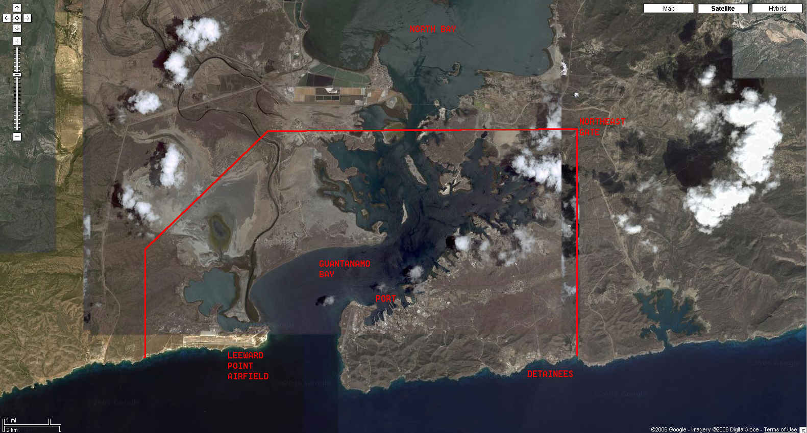
| Overview of Guantanamo Bay Looking West
|
|
| Google
Maps Source
|
|
| The Port
|
Google
Maps Source (rotated 180 debrees)
|
|
![[Image]](pict16.jpg) |
![[Image]](pict27.jpg) |
![[Image]](pict28.jpg) |
![[Image]](pict33.jpg) |
![[Image]](pict2.jpg) |
![[Image]](pict17.jpg) |
![[Image]](pict18.jpg) |
| Former McCalla Airfield
|
McCalla Airfield with Temporary Refugee Camp
|
|
Google
Maps Source
|
| Coast Guard Watch Station at Cuban Border
|
Google
Maps Source
|
| Border Sentry
|
Northeast Gate for Cuban Workers
|
| Leeward Point Airfield
|
Google
Maps Source
|
![[Image]](pict22.jpg) |
![[Image]](pict10.jpg)
|
![[Image]](pict13.jpg)
|
![[Image]](pict19.jpg)
|
| Water Desalinization and Power Plant
|
Google
Maps Source (rotated 180 degrees)
|
![[Image]](pict21.jpg) |
![[Image]](pict20.jpg) |
![[Image]](pict12.jpg) |
![[Image]](pict11.jpg) |
![[Image]](pict5.jpg)
![[Image]](pict4.jpg)
![[Image]](pict43.jpg)
![[Image]](pict15.jpg)
![[Image]](pict40.jpg)
![[Image]](pict1.jpg)
![[Image]](pict30.jpg)
![[Image]](pict32.jpg)
![[Image]](pict23.jpg)
![[Image]](pict34.jpg)
![[Image]](pict8.jpg)
![[Image]](pict9.jpg)
![[Image]](pict7.jpg)
![[Image]](pict6.jpg)
![[Image]](pict14.jpg)
![[Image]](pict37.jpg)
![[Image]](pict29.jpg)
![[Image]](pict39.jpg)